
Topografische kaart Roeland Park
Interactieve kaart
Klik op de kaart om de hoogte weer te geven.
Over deze kaart
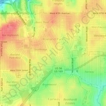
Naam: Topografische kaart Roeland Park, hoogte, reliëf.
Locatie: Roeland Park, Johnson County, Kansas, 66205, United States (39.02375 -94.65056 39.04408 -94.62116)
Gemiddelde hoogte: 291 m
Minimale hoogte: 254 m
Maximale hoogte: 315 m
Andere topografische kaarten
Klik op een kaart om zijn topografie, zijn hoogte en zijn reliëf te bekijken.
Prairie Highlands
United States > Kansas > Johnson County > Olathe
Prairie Highlands, Olathe, Johnson County, Kansas, 66031, United States
Gemiddelde hoogte: 314 m
Clearview City
United States > Kansas > Johnson County > De Soto
Clearview City, De Soto, Johnson County, Kansas, 66019, United States
Gemiddelde hoogte: 273 m
Fairway
United States > Kansas > Johnson County
Fairway, Johnson County, Kansas, United States
Gemiddelde hoogte: 290 m
Gardner
United States > Kansas > Johnson County
Gardner, Johnson County, Kansas, United States
Gemiddelde hoogte: 317 m
Overland Park
United States > Kansas > Johnson County
Overland Park, Johnson County, Kansas, United States
Gemiddelde hoogte: 300 m
Overland Park Arboretum and Botanical Gardens
United States > Kansas > Johnson County > Overland Park
Overland Park Arboretum and Botanical Gardens, Overland Park, Johnson County, Kansas, United States
Gemiddelde hoogte: 305 m
Holliday
United States > Kansas > Johnson County > Shawnee
Holliday, Shawnee, Johnson County, Kansas, 66218, United States
Gemiddelde hoogte: 252 m
Shawnee
United States > Kansas > Johnson County
Shawnee, Johnson County, Kansas, United States
Gemiddelde hoogte: 285 m
Spring Hill
United States > Kansas > Johnson County
Spring Hill, Johnson County, Kansas, 66083, United States
Gemiddelde hoogte: 317 m
Zarah
United States > Kansas > Johnson County > Shawnee
Zarah, Shawnee, Johnson County, Kansas, 66218, United States
Gemiddelde hoogte: 268 m
Olathe
United States > Kansas > Johnson County
Olathe, Johnson County, Kansas, United States
Gemiddelde hoogte: 309 m
Prairie Village
United States > Kansas > Johnson County
Prairie Village, Johnson County, Kansas, United States
Gemiddelde hoogte: 300 m
Leawood
United States > Kansas > Johnson County
Leawood, Johnson County, Kansas, United States
Gemiddelde hoogte: 289 m
Stilwell
United States > Kansas > Johnson County > Aubry
Stilwell, Aubry, Johnson County, Kansas, 66013, United States
Gemiddelde hoogte: 326 m
Merriam
United States > Kansas > Johnson County
Merriam, Johnson County, Kansas, United States
Gemiddelde hoogte: 306 m
De Soto
United States > Kansas > Johnson County
De Soto, Johnson County, Kansas, United States
Gemiddelde hoogte: 276 m
Leawood
United States > Kansas > Johnson County
Leawood, Johnson County, Kansas, 64114, United States
Gemiddelde hoogte: 286 m
Overland Park
United States > Kansas > Johnson County > Overland Park
Overland Park, Johnson County, Kansas, 66204, United States
Gemiddelde hoogte: 288 m
Olathe
United States > Kansas > Johnson County > Olathe
Olathe, Johnson County, Kansas, 6601, United States
Gemiddelde hoogte: 302 m
Elmhurst
United States > Kansas > Johnson County > Overland Park > Elmhurst
Elmhurst, Overland Park, Johnson County, Kansas, 66204, United States
Gemiddelde hoogte: 313 m
Lenexa
United States > Kansas > Johnson County > Lenexa
Lenexa, Johnson County, Kansas, 66219, United States
Gemiddelde hoogte: 290 m
Mission
United States > Kansas > Johnson County
Mission, Johnson County, Kansas, 66202, United States
Gemiddelde hoogte: 301 m
Lake Quivira
United States > Kansas > Johnson County
Lake Quivira, Johnson County, Kansas, United States
Gemiddelde hoogte: 269 m
Lenexa
United States > Kansas > Johnson County
Lenexa, Johnson County, Kansas, United States
Gemiddelde hoogte: 301 m
Mission Hills
United States > Kansas > Johnson County
Mission Hills, Johnson County, Kansas, United States
Gemiddelde hoogte: 288 m
Edgerton
United States > Kansas > Johnson County > Edgerton
Edgerton, Johnson County, Kansas, United States
Gemiddelde hoogte: 308 m