
Topografische kaart St. Joseph Island
Interactieve kaart
Klik op de kaart om de hoogte weer te geven.
St. Joseph Island
Its highest point, known colloquially and by surveyors as "the Mountain," is near the centre of the island near Carterton with an elevation of 345.6 m, which is about 169 m above Lake Huron.
Over deze kaart
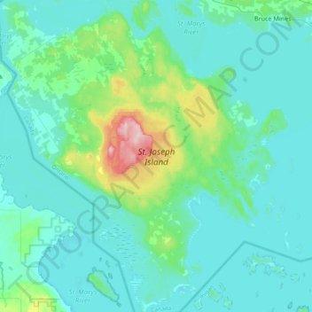
Naam: Topografische kaart St. Joseph Island, hoogte, reliëf.
Gemiddelde hoogte: 196 m
Minimale hoogte: 171 m
Maximale hoogte: 348 m