
Topografische kaart Pavia
Interactieve kaart
Klik op de kaart om de hoogte weer te geven.
Over deze kaart
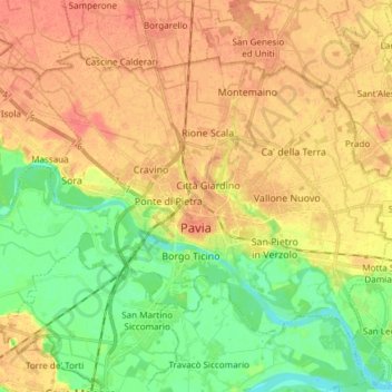
Naam: Topografische kaart Pavia, hoogte, reliëf.
Locatie: Pavia, Lombardy, 27100, Italy (45.15574 9.09038 45.23331 9.24055)
Gemiddelde hoogte: 74 m
Minimale hoogte: 50 m
Maximale hoogte: 93 m
From an elevation point of view, the city has various heights. The highest point is located in the area of the Visconti Castle, about 80 m (260 ft) above sea level, and then slowly declines. From an altitude of 80 m (260 ft), you pass to 77 m (253 ft) in about 500 m (550 yd; 1,600 ft). Downstream from Piazza Vittoria, where the cardo and decumanus of the Roman city crossed, the slope becomes more pronounced, up to just under 60 m (200 ft) above sea level near the Ponte Coperto.
Andere topografische kaarten
Klik op een kaart om zijn topografie, zijn hoogte en zijn reliëf te bekijken.
Cegni
Italy > Lombardy > Pavia > Santa Margherita di Staffora
Cegni, Santa Margherita di Staffora, Pavia, Lombardy, Italy
Gemiddelde hoogte: 927 m
Parco del Ticinello
Italy > Lombardy > Pavia > Siziano
Parco del Ticinello, Bettola, Siziano, Pavia, Lombardy, Italy
Gemiddelde hoogte: 91 m