
Topografische kaart Gopeshwar
Interactieve kaart
Klik op de kaart om de hoogte weer te geven.
Over deze kaart
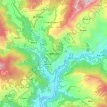
Naam: Topografische kaart Gopeshwar, hoogte, reliëf.
Gemiddelde hoogte: 1.566 m
Minimale hoogte: 895 m
Maximale hoogte: 2.725 m
Gopeshwar is located at 30°25′N 79°20′E / 30.42°N 79.33°E / 30.42; 79.33. It has an average elevation of 1,450 m (4,760 ft). Gopeshwar is 8.4 km (5.2 mi) away from Chamoli which is located on the banks of Alaknanda river and along NH 58. Gopeshwar is able to captivate any visitor with its mystic charm and pristine beauty. There are multiple snow-capped hills and peaks visible from Gopeshwar.
Andere topografische kaarten
Klik op een kaart om zijn topografie, zijn hoogte en zijn reliëf te bekijken.
Matharpal
India > Uttarakhand > Chamoli Tehsil > Sartoli
Matharpal, Sartoli, Chamoli Tehsil, Chamoli district, Uttarakhand, 246449, India
Gemiddelde hoogte: 1.445 m
Khamila Top
India > Uttarakhand > Chamoli Tehsil
Khamila Top, Chamoli Tehsil, Chamoli district, Uttarakhand, India
Gemiddelde hoogte: 3.676 m
Roopkund Lake
India > Uttarakhand > Chamoli Tehsil
Roopkund Lake, Chamoli Tehsil, Chamoli district, Uttarakhand, India
Gemiddelde hoogte: 4.631 m