
Topografische kaart Sandymount
Interactieve kaart
Klik op de kaart om de hoogte weer te geven.
Over deze kaart
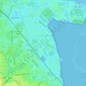
Naam: Topografische kaart Sandymount, hoogte, reliëf.
Gemiddelde hoogte: 5 m
Minimale hoogte: -4 m
Maximale hoogte: 20 m
Andere topografische kaarten
Klik op een kaart om zijn topografie, zijn hoogte en zijn reliëf te bekijken.
Finglas East
Ireland > County Dublin > Dublin
Finglas East, Finglas, Ballygall A ED, Dublin, County Dublin, Leinster, Ireland
Gemiddelde hoogte: 57 m
Dublin (Finglas)
Ireland > County Dublin > Dublin
Dublin (Finglas), Dublin, Fingal, County Dublin, Leinster, Ireland
Gemiddelde hoogte: 48 m
Crumlin
Ireland > County Dublin > Dublin
Crumlin, Walkinstown C ED, Dublin, County Dublin, Leinster, Ireland
Gemiddelde hoogte: 43 m
Belcamp
Ireland > County Dublin > Dublin
Belcamp, Priorswood B ED, Dublin, County Dublin, Leinster, Ireland
Gemiddelde hoogte: 37 m
North Bull Island
Ireland > County Dublin > Dublin
North Bull Island, Raheny B ED, Dublin, County Dublin, Leinster, Ireland
Gemiddelde hoogte: 2 m