
Topografische kaart Nathdwara
Interactieve kaart
Klik op de kaart om de hoogte weer te geven.
Nathdwara
Nathdwara is located at 24°56′N 73°49′E / 24.93°N 73.82°E / 24.93; 73.82. It has an average elevation of 584 metres (1919 ft). Located just 48 km north-east of Udaipur in Rajasthan, this town is easily reached by air, road or nearest rail-head.
Over deze kaart
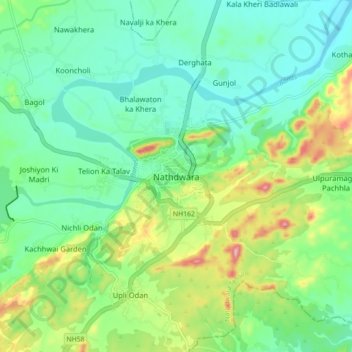
Naam: Topografische kaart Nathdwara, hoogte, reliëf.
Gemiddelde hoogte: 590 m
Minimale hoogte: 538 m
Maximale hoogte: 713 m