
Topografische kaart Αγιόκαμπος
Interactieve kaart
Klik op de kaart om de hoogte weer te geven.
Over deze kaart
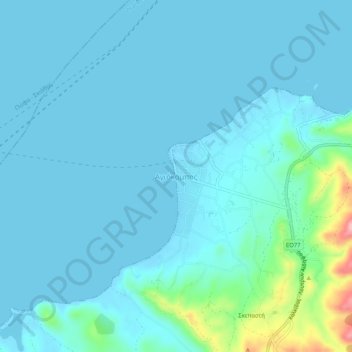
Naam: Topografische kaart Αγιόκαμπος, hoogte, reliëf.
Gemiddelde hoogte: 16 m
Minimale hoogte: -2 m
Maximale hoogte: 142 m
Andere topografische kaarten
Klik op een kaart om zijn topografie, zijn hoogte en zijn reliëf te bekijken.
Chalcis
Grèce > Thessalie-Grèce centrale > Περιφερειακή Ενότητα Ευβοίας
Chalcis, Δήμος Χαλκιδέων, Περιφερειακή Ενότητα Ευβοίας, Grèce-Centrale, Thessalie-Grèce centrale, 341 09, Grèce
Gemiddelde hoogte: 129 m
Κύμη
Grèce > Thessalie-Grèce centrale > Περιφερειακή Ενότητα Ευβοίας
Κύμη, Δήμος Κύμης - Αλιβερίου, Περιφερειακή Ενότητα Ευβοίας, Grèce-Centrale, Thessalie-Grèce centrale, 340 03, Grèce
Gemiddelde hoogte: 195 m
Profitis Ilias
Grèce > Thessalie-Grèce centrale > Περιφερειακή Ενότητα Ευβοίας > Chalcis > Profitis Ilias
Profitis Ilias, Chalcis, Δήμος Χαλκιδέων, Περιφερειακή Ενότητα Ευβοίας, Grèce-Centrale, Thessalie-Grèce centrale, 341 00, Grèce
Gemiddelde hoogte: 276 m
Φαράκλα
Grèce > Thessalie-Grèce centrale > Περιφερειακή Ενότητα Ευβοίας
Φαράκλα, Δήμος Μαντουδίου - Λίμνης - Αγίας Άννας, Περιφερειακή Ενότητα Ευβοίας, Grèce-Centrale, Thessalie-Grèce centrale, 340 04, Grèce
Gemiddelde hoogte: 100 m