
Topografische kaart Reigate
Klik op de kaart om de hoogte weer te geven.
Reigate
Reigate is in central Surrey, around 19 mi (30 km) south of central London and 9 mi (14 km) north of Gatwick Airport. The town is in the Vale of Holmesdale, below the North Downs escarpment. The average elevation in the centre is 80 m (260 ft) above ordnance datum (OD) and the area is drained by the Wallace Brook and its tributaries, which feed the River Mole.
Over deze kaart
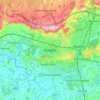
Naam: Topografische kaart Reigate, hoogte, reliëf.
Gemiddelde hoogte: 100 m
Minimale hoogte: 43 m
Maximale hoogte: 236 m
Andere topografische kaarten
Klik op een kaart om zijn topografie, zijn hoogte en zijn reliëf te bekijken.
Lower Earlswood Lake
United Kingdom > England > Surrey > Reigate and Banstead > Redhill
Gemiddelde hoogte: 75 m
Redhill Common
United Kingdom > England > Surrey > Reigate and Banstead > Redhill
Gemiddelde hoogte: 92 m
Banstead Wood
United Kingdom > England > Surrey > Reigate and Banstead > Chipstead
Gemiddelde hoogte: 145 m
Reigate Park
United Kingdom > England > Surrey > Reigate and Banstead > Reigate
Gemiddelde hoogte: 80 m
Horley
United Kingdom > England > Surrey > Reigate and Banstead
Horley is at an altitude of around 54 m (177 ft) above mean sea level.
Gemiddelde hoogte: 58 m