
Topografische kaart Fontaine
Interactieve kaart
Klik op de kaart om de hoogte weer te geven.
Over deze kaart
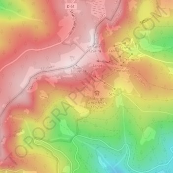
Naam: Topografische kaart Fontaine, hoogte, reliëf.
Gemiddelde hoogte: 1.079 m
Minimale hoogte: 761 m
Maximale hoogte: 1.282 m
Andere topografische kaarten
Klik op een kaart om zijn topografie, zijn hoogte en zijn reliëf te bekijken.
Trois Fours
France > Grand Est > Haut-Rhin > Stosswihr
Trois Fours, Stosswihr, Colmar-Ribeauvillé, Haut-Rhin, Grand Est, France métropolitaine, 68140, France
Gemiddelde hoogte: 1.037 m
Ampfersbach
France > Grand Est > Haut-Rhin > Stosswihr
Ampfersbach, Stosswihr, Colmar-Ribeauvillé, Haut-Rhin, Grand Est, France métropolitaine, 68140, France
Gemiddelde hoogte: 634 m