
Topografische kaart Giridih
Interactieve kaart
Klik op de kaart om de hoogte weer te geven.
Over deze kaart
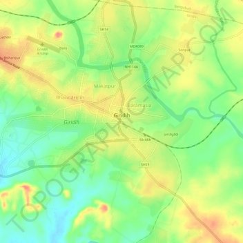
Naam: Topografische kaart Giridih, hoogte, reliëf.
Locatie: Giridih, Giridih District, Jharkhand, 815301, India (24.16335 86.26662 24.20615 86.32650)
Gemiddelde hoogte: 292 m
Minimale hoogte: 261 m
Maximale hoogte: 326 m
Giridih is located at 24°11′N 86°18′E / 24.18°N 86.3°E / 24.18; 86.3. It has an average elevation of 289 metres (948 ft). Śrī Sammed Shikharji also known as the Parasnath Hills, located in Giridih district is the highest mountain peak in Jharkhand. It is a conical granite peak located 4,477 feet (1,365 metres) above the sea level.
Andere topografische kaarten
Klik op een kaart om zijn topografie, zijn hoogte en zijn reliëf te bekijken.