
Topografische kaart Aurora Springs
Interactieve kaart
Klik op de kaart om de hoogte weer te geven.
Over deze kaart
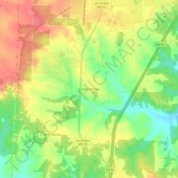
Naam: Topografische kaart Aurora Springs, hoogte, reliëf.
Gemiddelde hoogte: 274 m
Minimale hoogte: 231 m
Maximale hoogte: 314 m
Andere topografische kaarten
Klik op een kaart om zijn topografie, zijn hoogte en zijn reliëf te bekijken.
Lake Ozark
United States > Missouri > Miller County
Lake Ozark, Miller County, Missouri, United States
Gemiddelde hoogte: 213 m
Lakeside
United States > Missouri > Miller County
Lakeside, Miller County, Missouri, United States
Gemiddelde hoogte: 209 m
Bagnell
United States > Missouri > Miller County
Bagnell, Miller County, Missouri, United States
Gemiddelde hoogte: 198 m
High Point
United States > Missouri > Miller County
High Point, Miller County, Missouri, United States
Gemiddelde hoogte: 252 m
Tuscumbia
United States > Missouri > Miller County
Tuscumbia, Miller County, Missouri, United States
Gemiddelde hoogte: 198 m
Rocky Mount
United States > Missouri > Miller County
Rocky Mount, Miller County, Missouri, United States
Gemiddelde hoogte: 278 m
Saint Elizabeth
United States > Missouri > Miller County > St. Elizabeth
Saint Elizabeth, St. Elizabeth, Miller County, Missouri, 65075, United States
Gemiddelde hoogte: 216 m
Eldon
United States > Missouri > Miller County
Eldon, Miller County, Missouri, United States
Gemiddelde hoogte: 280 m