
Topografische kaart Kudremukha
Interactieve kaart
Klik op de kaart om de hoogte weer te geven.
Over deze kaart
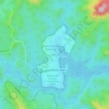
Naam: Topografische kaart Kudremukha, hoogte, reliëf.
Gemiddelde hoogte: 858 m
Minimale hoogte: 775 m
Maximale hoogte: 1.239 m
The town of Kudremukha (KIOCL & etc.) lies at an elevation of around 815 metres (2,674 ft), whereas the peak stands at 1,894 metres (6,214 ft). The southern and western sides of the park form the steep slope of the Western Ghats ridgeline, with the altitude varying from 100 m - 1892 m (peak). The northern, central, and eastern portions of the park constitute a chain of rolling hills with a mosaic of natural grassland and shola forests. Kudremukha receives an average annual rainfall of 7000 mm, largely due to the forest types of mainly evergreen vegetation that can be found here.
Andere topografische kaarten
Klik op een kaart om zijn topografie, zijn hoogte en zijn reliëf te bekijken.
Kalasa
India > Karnataka > Kalasa taluk
Kalasa, Kalasa taluk, Chikkamagaluru District, Karnataka, 577124, India
Gemiddelde hoogte: 897 m
Horanadu
India > Karnataka > Kalasa taluk
Horanadu, Kalasa taluk, Chikkamagaluru District, Karnataka, 577181, India
Gemiddelde hoogte: 1.022 m