
Topografische kaart Independence
Interactieve kaart
Klik op de kaart om de hoogte weer te geven.
Over deze kaart
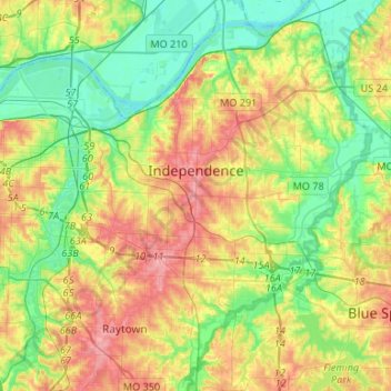
Naam: Topografische kaart Independence, hoogte, reliëf.
Locatie: Independence, Jackson County, Missouri, United States (39.01768 -94.48150 39.13987 -94.21601)
Gemiddelde hoogte: 261 m
Minimale hoogte: 215 m
Maximale hoogte: 330 m
Andere topografische kaarten
Klik op een kaart om zijn topografie, zijn hoogte en zijn reliëf te bekijken.
Cobbler
United States > Missouri > Jackson County
Cobbler, Jackson County, Missouri, 64058, United States
Gemiddelde hoogte: 237 m
Lee's Summit
United States > Missouri > Jackson County
Lee's Summit, Jackson County, Missouri, United States
Gemiddelde hoogte: 291 m
Kansas City
United States > Missouri > Jackson County
Kansas City, Jackson County, Missouri, United States
Gemiddelde hoogte: 277 m
Downtown Kansas City
United States > Missouri > Jackson County > Downtown Kansas City
Kansas City, Downtown Kansas City, Jackson County, Missouri, 64106-2303, United States
Gemiddelde hoogte: 271 m
Lee's Summit
United States > Missouri > Jackson County > Lee's Summit
Lee's Summit, Jackson County, Missouri, 64081, United States
Gemiddelde hoogte: 288 m
Jackson County
United States > Missouri > Jackson County
Jackson County, Missouri, United States
Gemiddelde hoogte: 268 m