
Topografische kaart Washington
Interactieve kaart
Klik op de kaart om de hoogte weer te geven.
Over deze kaart
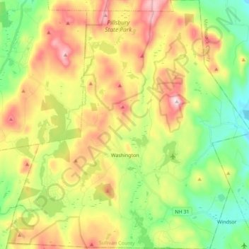
Naam: Topografische kaart Washington, hoogte, reliëf.
Gemiddelde hoogte: 466 m
Minimale hoogte: 265 m
Maximale hoogte: 742 m
Lovewell Mountain, located northeast of the town center and with an elevation of 2,496 feet (761 m), is the highest point in town. As Edwin A. Charlton writes in New Hampshire As It Is (1855), the mountain "received its name from Captain John Lovewell, who was accustomed to ascend it for the purpose of discovering the wigwams of the Indians, and who, on one occasion, killed seven Indians near its summit." The Washington Town Common, elevation 1,507 feet (459 m), is the highest town center in the state. (The town hall of Clarksville in northern New Hampshire is located at a higher elevation—1,980 feet (600 m)—but there is no other village development there.)
Andere topografische kaarten
Klik op een kaart om zijn topografie, zijn hoogte en zijn reliëf te bekijken.
Croydon
United States > New Hampshire > Sullivan County
Croydon, Sullivan County, New Hampshire, United States
Gemiddelde hoogte: 372 m
Plainfield
United States > New Hampshire > Sullivan County
Plainfield, Sullivan County, New Hampshire, United States
Gemiddelde hoogte: 267 m
Unity
United States > New Hampshire > Sullivan County
Unity, Sullivan County, New Hampshire, United States
Gemiddelde hoogte: 369 m
Lempster
United States > New Hampshire > Sullivan County
Lempster, Sullivan County, New Hampshire, 03605, United States
Gemiddelde hoogte: 425 m
Springfield
United States > New Hampshire > Sullivan County > Springfield
Springfield, Sullivan County, New Hampshire, United States
Gemiddelde hoogte: 416 m
Charlestown
United States > New Hampshire > Sullivan County
Charlestown, Sullivan County, New Hampshire, 03603, United States
Gemiddelde hoogte: 256 m
Claremont
United States > New Hampshire > Sullivan County
Claremont, Sullivan County, New Hampshire, United States
Gemiddelde hoogte: 236 m