
Doe een donatie
Rust jezelf uit voor je volgende avontuur:
Als Amazon-partner verdient deze site een commissie op in aanmerking komende aankopen, zonder extra kosten voor jou.
Topografische kaart Brooklyn
Klik op de kaart om de hoogte weer te geven.
Doe een donatie
Rust jezelf uit voor je volgende avontuur:
Als Amazon-partner verdient deze site een commissie op in aanmerking komende aankopen, zonder extra kosten voor jou.
Brooklyn
Brooklyn’s topography is shaped by its position on western Long Island, where low coastal plains, harbor margins, and glacial landforms meet in a densely urbanized landscape. Much of southern and eastern Brooklyn forms a gently sloping outwash plain that descends toward Jamaica Bay, Coney Island, Gravesend Bay, and the Atlantic-facing shore, while the central and northwestern parts rise into a modest but distinct belt of hills associated with the terminal moraine that runs through Brooklyn and Queens. This moraine gives areas around Prospect Park, Park Slope, Sunset Park, and Green-Wood Cemetery a more rolling physical character, with short ridges, knolls, and locally sharper relief compared with the flatter coastal neighborhoods. Green-Wood’s Battle Hill is widely identified as Brooklyn’s highest natural point, standing a little over 200 ft above sea level, and it illustrates how the borough’s most pronounced elevations are glacial rather than bedrock mountain forms. Overall, Brooklyn presents a subdued but varied urban terrain: low tidal edges and reclaimed waterfronts around the harbor, broad sandy plains toward the south, and a central moraine ridge that provides the borough’s main elevation contrast and long views across New York Harbor.
Doe een donatie
Rust jezelf uit voor je volgende avontuur:
Als Amazon-partner verdient deze site een commissie op in aanmerking komende aankopen, zonder extra kosten voor jou.
Over deze kaart
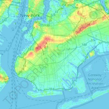
Naam: Topografische kaart Brooklyn, hoogte, reliëf.
Locatie: Brooklyn, Kings County, New York, United States (40.55034 -74.05669 40.73943 -73.83295)
Gemiddelde hoogte: 9 m
Minimale hoogte: -10 m
Maximale hoogte: 62 m
Doe een donatie
Rust jezelf uit voor je volgende avontuur:
Als Amazon-partner verdient deze site een commissie op in aanmerking komende aankopen, zonder extra kosten voor jou.
Andere topografische kaarten
Klik op een kaart om zijn topografie, zijn hoogte en zijn reliëf te bekijken.
Brooklyn Bridge Park
United States > New York > Kings County > New York
Brooklyn Bridge Park spans 85 acres (34 ha) of the East River waterfront in the Brooklyn Heights and Dumbo neighborhoods of Brooklyn. The park is divided into eleven sections: Piers 1 through 6; Fulton Ferry Landing; Brooklyn Bridge Plaza; Empire Fulton Ferry; Main Street; and John Street. Each of these…
Gemiddelde hoogte: 9 m
Doe een donatie
Rust jezelf uit voor je volgende avontuur:
Als Amazon-partner verdient deze site een commissie op in aanmerking komende aankopen, zonder extra kosten voor jou.