
Topografische kaart Ottawa
Interactieve kaart
Klik op de kaart om de hoogte weer te geven.
Over deze kaart
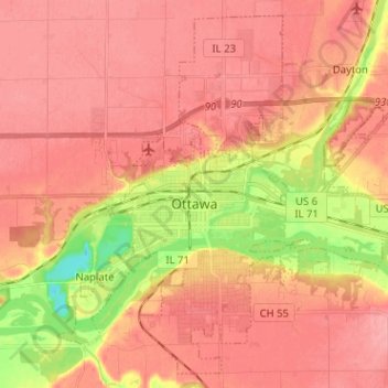
Naam: Topografische kaart Ottawa, hoogte, reliëf.
Locatie: Ottawa, LaSalle County, Illinois, 61350, United States (41.30969 -88.89043 41.39794 -88.76318)
Gemiddelde hoogte: 173 m
Minimale hoogte: 113 m
Maximale hoogte: 200 m
Andere topografische kaarten
Klik op een kaart om zijn topografie, zijn hoogte en zijn reliëf te bekijken.
Seneca
United States > Illinois > LaSalle County
Seneca, LaSalle County, Illinois, United States
Gemiddelde hoogte: 180 m
Peru
United States > Illinois > LaSalle County
Peru, LaSalle County, Illinois, 61354, United States
Gemiddelde hoogte: 180 m
LaSalle
United States > Illinois > LaSalle County
LaSalle, LaSalle County, Illinois, 61301, United States
Gemiddelde hoogte: 180 m
Lower Fox River - Blakes Landing Nature Preserve
United States > Illinois > LaSalle County > Blakes
Lower Fox River - Blakes Landing Nature Preserve, Blakes, LaSalle County, Illinois, 60557, United States
Gemiddelde hoogte: 182 m
Starved Rock
United States > Illinois > LaSalle County
Starved Rock, LaSalle County, Illinois, 61373, United States
Gemiddelde hoogte: 160 m
Marseilles
United States > Illinois > LaSalle County > Marseilles
Marseilles, LaSalle County, Illinois, 61341, United States
Gemiddelde hoogte: 189 m
North Utica
United States > Illinois > LaSalle County
North Utica, LaSalle County, Illinois, 61373, United States
Gemiddelde hoogte: 175 m
Oglesby
United States > Illinois > LaSalle County
Oglesby, LaSalle County, Illinois, 61348, United States
Gemiddelde hoogte: 177 m
Earlville
United States > Illinois > LaSalle County
Earlville, LaSalle County, Illinois, 60518, United States
Gemiddelde hoogte: 214 m
Grand Ridge
United States > Illinois > LaSalle County
Grand Ridge, LaSalle County, Illinois, United States
Gemiddelde hoogte: 196 m