
Topografische kaart Hagerstown
Interactieve kaart
Klik op de kaart om de hoogte weer te geven.
Over deze kaart
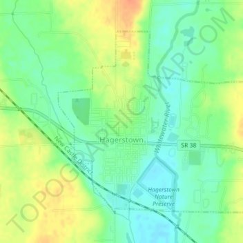
Naam: Topografische kaart Hagerstown, hoogte, reliëf.
Locatie: Hagerstown, Wayne County, Indiana, United States (39.90306 -85.17084 39.92317 -85.14325)
Gemiddelde hoogte: 312 m
Minimale hoogte: 295 m
Maximale hoogte: 335 m
Terrain surrounding Hagerstown consists of flat land at an elevation of roughly 1000 feet above sea level that is used primarily for agriculture.
Andere topografische kaarten
Klik op een kaart om zijn topografie, zijn hoogte en zijn reliëf te bekijken.
Spring Grove
United States > Indiana > Wayne County
Spring Grove, Wayne County, Indiana, United States
Gemiddelde hoogte: 300 m
Boston
United States > Indiana > Wayne County
Boston, Wayne County, Indiana, 47324, United States
Gemiddelde hoogte: 344 m
Cambridge City
United States > Indiana > Wayne County
Cambridge City, Wayne County, Indiana, United States
Gemiddelde hoogte: 292 m
Richmond
United States > Indiana > Wayne County
Richmond, Wayne County, Indiana, 47374, United States
Gemiddelde hoogte: 314 m
Economy
United States > Indiana > Wayne County
Economy, Wayne County, Indiana, United States
Gemiddelde hoogte: 345 m