
Topografische kaart Posthudorra/Porto Torres
Interactieve kaart
Klik op de kaart om de hoogte weer te geven.
Posthudorra/Porto Torres
The morphology of "city part" is flat; the area of Porto Torres and the rest of north-west Sardinia is characterized by a Nurra plain, with some hill formations in the middle of it. Part of this hill formation is in the municipality of Porto Torres, the highest elevation being Monte Alvaro, rising to a height of 342 m above sea level.
Over deze kaart
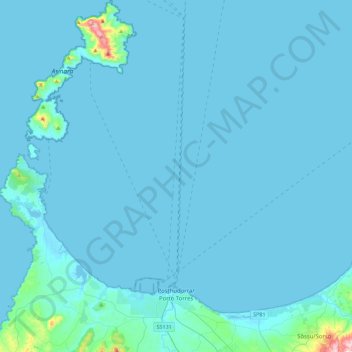
Naam: Topografische kaart Posthudorra/Porto Torres, hoogte, reliëf.
Locatie: Posthudorra/Porto Torres, Sassari, Sardinia, 07046, Italy (40.78142 8.20876 41.12073 8.45885)
Gemiddelde hoogte: 15 m
Minimale hoogte: -1 m
Maximale hoogte: 418 m
Andere topografische kaarten
Klik op een kaart om zijn topografie, zijn hoogte en zijn reliëf te bekijken.