
Topografische kaart Old Stone Fort State Archaeological Park
Interactieve kaart
Klik op de kaart om de hoogte weer te geven.
Over deze kaart
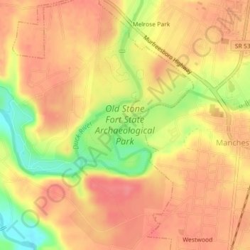
Naam: Topografische kaart Old Stone Fort State Archaeological Park, hoogte, reliëf.
Gemiddelde hoogte: 316 m
Minimale hoogte: 268 m
Maximale hoogte: 339 m
The Duck River system spills over a limestone-rich shelf of the western Cumberland Plateau known as the Highland Rim. As the Duck and Little Duck approach their convergence, they rapidly drop in elevation, and have cut relatively deep gorges around the peninsula upon which the ancient structure is located. Both gorges are highlighted by a series of substantial waterfalls and whitewater rapids. The natural waterpower in these two gorges attracted entrepreneurs and millwrights throughout the 19th century.
Andere topografische kaarten
Klik op een kaart om zijn topografie, zijn hoogte en zijn reliëf te bekijken.
Glenview
United States > Tennessee > Coffee County > Manchester
Glenview, Manchester, Coffee County, Middle Tennessee, Tennessee, 37355, United States
Gemiddelde hoogte: 322 m
White Oaks
United States > Tennessee > Coffee County > Manchester
White Oaks, Manchester, Coffee County, Tennessee, 38505, United States
Gemiddelde hoogte: 325 m
Belmont
United States > Tennessee > Coffee County > Manchester
Belmont, Manchester, Coffee County, Middle Tennessee, Tennessee, United States
Gemiddelde hoogte: 320 m
Royal Oaks
United States > Tennessee > Coffee County > Manchester > Royal Oaks
Royal Oaks, Manchester, Coffee County, Tennessee, 38505, United States
Gemiddelde hoogte: 326 m
Westwood
United States > Tennessee > Coffee County > Manchester > Westwood
Westwood, Manchester, Coffee County, Tennessee, 37183:37355, United States
Gemiddelde hoogte: 322 m