
Topografische kaart Raon-l'Étape
Interactieve kaart
Klik op de kaart om de hoogte weer te geven.
Over deze kaart
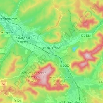
Naam: Topografische kaart Raon-l'Étape, hoogte, reliëf.
Gemiddelde hoogte: 362 m
Minimale hoogte: 219 m
Maximale hoogte: 604 m
Raon-l'Étape is positioned at the mouth of the Plaine [fr] at the point where it converges into the Meurthe, itself a tributary of the Moselle. Because it is on departmental frontier with the adjacent Meurthe-et-Moselle département, Raon-l'Étape is sometimes known as the "Gateway to the Vosges" (porte des Vosges). The town is positioned at a point where relatively flat lands transform into a much more mountainous topography: the mountains have for centuries restricted the options for travellers between francophone France and Alsace (formerly the western reaches of the Empire on the other side of the Vosges). The position of Raon has therefore been critical to influencing the movements of merchandise in peace time and of armies in war time for many centuries.
Andere topografische kaarten
Klik op een kaart om zijn topografie, zijn hoogte en zijn reliëf te bekijken.
Dogneville
Dogneville, Épinal, Vosges, Grand Est, Metropolitan France, 88000, France
Gemiddelde hoogte: 337 m
Les Plombes
France > Grand Est > Vosges > Xonrupt-Longemer
Les Plombes, Xonrupt-Longemer, Saint-Dié-des-Vosges, Vosges, Grand Est, Metropolitan France, 88400, France
Gemiddelde hoogte: 882 m
Les Sources
France > Grand Est > Vosges > Bussang
Les Sources, Bussang, Épinal, Vosges, Grand Est, Metropolitan France, 88540, France
Gemiddelde hoogte: 806 m
Ramberchamp
France > Grand Est > Vosges > Gérardmer
Ramberchamp, Gérardmer, Saint-Dié-des-Vosges, Vosges, Grand Est, Metropolitan France, 88400, France
Gemiddelde hoogte: 786 m
La Petite-Fosse
La Petite-Fosse, Saint-Dié-des-Vosges, Vosges, Grand Est, Metropolitan France, 88490, France
Gemiddelde hoogte: 565 m
Maxey-sur-Meuse
Maxey-sur-Meuse, Neufchâteau, Vosges, Grand Est, Metropolitan France, 88630, France
Gemiddelde hoogte: 325 m
La Vôge-les-Bains
France > Grand Est > Vosges > La Vôge-les-Bains
La Vôge-les-Bains, Épinal, Vosges, Grand Est, Metropolitan France, 88240, France
Gemiddelde hoogte: 379 m
Bellefontaine
Bellefontaine, Épinal, Vosges, Grand Est, Metropolitan France, 88370, France
Gemiddelde hoogte: 544 m
Neufchâteau
Neufchâteau, Vosges, Grand Est, Metropolitan France, 88300, France
Gemiddelde hoogte: 334 m
La Croix-aux-Mines
La Croix-aux-Mines, Saint-Dié-des-Vosges, Vosges, Grand Est, Metropolitan France, 88520, France
Gemiddelde hoogte: 705 m
Ménil-sur-Belvitte
Ménil-sur-Belvitte, Épinal, Vosges, Grand Est, Metropolitan France, 88700, France
Gemiddelde hoogte: 315 m