
Topografische kaart Halswell-Hornby-Riccarton Community
Interactieve kaart
Klik op de kaart om de hoogte weer te geven.
Over deze kaart
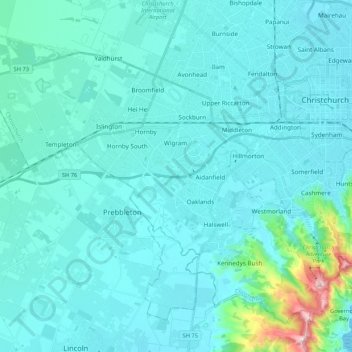
Naam: Topografische kaart Halswell-Hornby-Riccarton Community, hoogte, reliëf.
Gemiddelde hoogte: 49 m
Minimale hoogte: 0 m
Maximale hoogte: 526 m
Andere topografische kaarten
Klik op een kaart om zijn topografie, zijn hoogte en zijn reliëf te bekijken.
Aua / King Billy Island
Neuseeland > Canterbury > Christchurch City > Banks Peninsula Community
Aua / King Billy Island, Diamond Harbour, Banks Peninsula Community, Christchurch City, Canterbury, Neuseeland
Gemiddelde hoogte: 6 m
Christchurch
Neuseeland > Canterbury > Christchurch City
Christchurch, Christchurch City, Canterbury, Neuseeland
Gemiddelde hoogte: 41 m
Lyttelton
Neuseeland > Canterbury > Christchurch City > Banks Peninsula Community
Lyttelton, Banks Peninsula Community, Christchurch City, Canterbury, 8082, Neuseeland
Gemiddelde hoogte: 99 m