
Topografische kaart La Pépinière
Interactieve kaart
Klik op de kaart om de hoogte weer te geven.
Over deze kaart
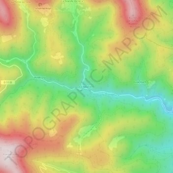
Naam: Topografische kaart La Pépinière, hoogte, reliëf.
Gemiddelde hoogte: 584 m
Minimale hoogte: 281 m
Maximale hoogte: 936 m
Andere topografische kaarten
Klik op een kaart om zijn topografie, zijn hoogte en zijn reliëf te bekijken.
Taennchel
France > Grand Est > Haut-Rhin > Ribeauvillé
Taennchel, Ribeauvillé, Colmar-Ribeauvillé, Haut-Rhin, Grand Est, France métropolitaine, 68150, France
Gemiddelde hoogte: 740 m
Schelmenkopf
France > Grand Est > Haut-Rhin > Ribeauvillé
Schelmenkopf, Ribeauvillé, Colmar-Ribeauvillé, Haut-Rhin, Grand Est, France métropolitaine, 68150, France
Gemiddelde hoogte: 681 m
Dusenbach
France > Grand Est > Haut-Rhin > Ribeauvillé
Dusenbach, Ribeauvillé, Colmar-Ribeauvillé, Haut-Rhin, Grand Est, France métropolitaine, 68150, France
Gemiddelde hoogte: 507 m
Chalet du Club Vosgiens Ribeauvillé
France > Grand Est > Haut-Rhin > Ribeauvillé > Schelmenkopf
Chalet du Club Vosgiens Ribeauvillé, Chemin du Schelmenkopf, Schelmenkopf, Ribeauvillé, Colmar-Ribeauvillé, Haut-Rhin, Grand Est, France métropolitaine, 68150, France
Gemiddelde hoogte: 700 m