Geolokaliseren

Topografische kaart San Antolín de Ibias

Interactieve kaart

Klik op de kaart om de hoogte weer te geven.

Over deze kaart

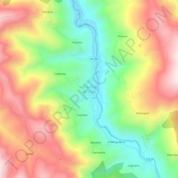
Naam: Topografische kaart San Antolín de Ibias, hoogte, reliëf.

Locatie: San Antolín de Ibias, Ibias, Asturias, España (43.01863 -6.89239 43.05863 -6.85239)

Gemiddelde hoogte: 550 m

Minimale hoogte: 245 m

Maximale hoogte: 884 m

Andere topografische kaarten

Klik op een kaart om zijn topografie, zijn hoogte en zijn reliëf te bekijken.

Peneda

España > Asturias > Ibias

Peneda, Ibias, Asturias, 33810, España

Gemiddelde hoogte: 651 m

Ibias

España > Asturias > Ibias

Ibias, Asturias, 33810, España

Gemiddelde hoogte: 914 m

Forna

España > Asturias > Ibias > Forna

Forna, Ibias, Asturias, España

Gemiddelde hoogte: 570 m

Ricabo

España > Asturias > Ibias

Ricabo, Ibias, Asturias, España

Gemiddelde hoogte: 476 m

Cecos

España > Asturias > Ibias

Cecos, Ibias, Asturias, España

Gemiddelde hoogte: 587 m