
Topografische kaart Hastinapur
Interactieve kaart
Klik op de kaart om de hoogte weer te geven.
Over deze kaart
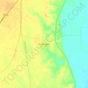
Naam: Topografische kaart Hastinapur, hoogte, reliëf.
Gemiddelde hoogte: 226 m
Minimale hoogte: 211 m
Maximale hoogte: 239 m
Present-day Hastinapur is a town in the Doab region of Uttar Pradesh in India, about 37 kilometres (23 mi) from Meerut and nearly 96 km (60 mi) north-east of Delhi on National Highway 34. It is a small township re-established by Jawaharlal Nehru on February 6, 1949, located at 29°10′N 78°01′E / 29.17°N 78.02°E / 29.17; 78.02. With an average elevation of 218 metres (715 ft), Hastinapur experiences temperatures ranging from 5 to 40 °C (41 to 104 °F). Summer season is from March to May, during which the temperatures range from 32 to 40 °C (90 to 104 °F). The monsoon season is from July to September, during which the temperature is relatively low. Winter lasts from December to February, with December usually being the coldest month of the year. During this time, temperatures can drop to around 5 °C (41 °F) and don't usually go above 14 °C (57 °F).
Andere topografische kaarten
Klik op een kaart om zijn topografie, zijn hoogte en zijn reliëf te bekijken.
Mawana
India > Uttar Pradesh > Mawana > Mawana
Mawana, Meerut, Uttar Pradesh, 250400, India
Gemiddelde hoogte: 230 m