
Topografische kaart Town of Souris
Interactieve kaart
Klik op de kaart om de hoogte weer te geven.
Over deze kaart
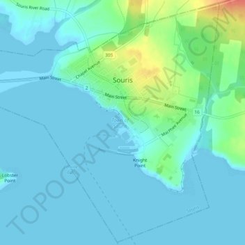
Naam: Topografische kaart Town of Souris, hoogte, reliëf.
Locatie: Town of Souris, Kings County, Prince Edward Island, Canada (46.33544 -62.27828 46.36650 -62.23225)
Gemiddelde hoogte: 9 m
Minimale hoogte: -1 m
Maximale hoogte: 51 m
Andere topografische kaarten
Klik op een kaart om zijn topografie, zijn hoogte en zijn reliëf te bekijken.
Monticello
Canada > Prince Edward Island > Kings County
Monticello, Kings County, Prince Edward Island, Canada
Gemiddelde hoogte: 21 m
Milburn
Canada > Prince Edward Island > Kings County
Milburn, Kings County, Prince Edward Island, Canada
Gemiddelde hoogte: 29 m
Cambridge
Canada > Prince Edward Island > Kings County
Cambridge, Kings County, Prince Edward Island, Canada
Gemiddelde hoogte: 17 m
Cable Head East
Canada > Prince Edward Island > Kings County
Cable Head East, Kings County, Prince Edward Island, Canada
Gemiddelde hoogte: 19 m
Mount Stewart
Canada > Prince Edward Island > Kings County
Mount Stewart, Kings County, Prince Edward Island, Canada
Gemiddelde hoogte: 38 m
Georgetown
Canada > Prince Edward Island > Kings County
Georgetown, Town of Three Rivers, Kings County, Prince Edward Island, Canada
Gemiddelde hoogte: 9 m
Canavoy
Canada > Prince Edward Island > Kings County
Canavoy, Kings County, Prince Edward Island, Canada
Gemiddelde hoogte: 15 m
Morell
Canada > Prince Edward Island > Kings County
Morell, Rural Municipality of Morell, Kings County, Prince Edward Island, Canada
Gemiddelde hoogte: 15 m
DeGros Marsh
Canada > Prince Edward Island > Kings County
DeGros Marsh, Town of Three Rivers, Kings County, Prince Edward Island, Canada
Gemiddelde hoogte: 10 m
Cardigan
Canada > Prince Edward Island > Kings County
Cardigan, Town of Three Rivers, Kings County, Prince Edward Island, Canada
Gemiddelde hoogte: 27 m
Saint Charles
Canada > Prince Edward Island > Kings County
Saint Charles, Kings County, Prince Edward Island, Canada
Gemiddelde hoogte: 36 m
Roseneath
Canada > Prince Edward Island > Kings County
Roseneath, Town of Three Rivers, Kings County, Prince Edward Island, Canada
Gemiddelde hoogte: 22 m
Souris
Canada > Prince Edward Island > Kings County > Souris
Souris, Kings County, Prince Edward Island, Canada
Gemiddelde hoogte: 33 m
Alliston
Canada > Prince Edward Island > Kings County
Alliston, Kings County, Prince Edward Island, Canada
Gemiddelde hoogte: 60 m
Poplar Point
Canada > Prince Edward Island > Kings County
Poplar Point, Rural Municipality of Central Kings, Kings County, Prince Edward Island, Canada
Gemiddelde hoogte: 19 m
Lower Montague
Canada > Prince Edward Island > Kings County > Lower Montague
Lower Montague, Town of Three Rivers, Kings County, Prince Edward Island, C0A 1R0, Canada
Gemiddelde hoogte: 15 m
Murray River
Canada > Prince Edward Island > Kings County > Murray River
Murray River, Kings County, Prince Edward Island, C0A 1W0, Canada
Gemiddelde hoogte: 34 m
Prince Edward Island National Park
Canada > Prince Edward Island > Kings County > Greenwich
Prince Edward Island National Park, Greenwich Road, Greenwich, Kings County, Prince Edward Island, Canada
Gemiddelde hoogte: 2 m