
Topografische kaart Devils Peak
Interactieve kaart
Klik op de kaart om de hoogte weer te geven.
Over deze kaart
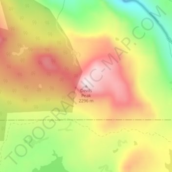
Naam: Topografische kaart Devils Peak, hoogte, reliëf.
Locatie: Devils Peak, Placer County, California, United States (39.02875 -120.29135 39.02885 -120.29125)
Gemiddelde hoogte: 2.042 m
Minimale hoogte: 1.745 m
Maximale hoogte: 2.296 m
Andere topografische kaarten
Klik op een kaart om zijn topografie, zijn hoogte en zijn reliëf te bekijken.
Roseville
United States > California > Placer County
Roseville, Placer County, California, United States
Gemiddelde hoogte: 61 m
Foresthill
United States > California > Placer County
Foresthill, Placer County, California, 95631, United States
Gemiddelde hoogte: 859 m
Rocklin
United States > California > Placer County
Rocklin, Placer County, California, United States
Gemiddelde hoogte: 95 m
Auburn
United States > California > Placer County
Auburn, Placer County, California, 95603, United States
Gemiddelde hoogte: 380 m
Lincoln
United States > California > Placer County > Lincoln
Lincoln, Placer County, California, United States
Gemiddelde hoogte: 34 m
Kings Beach
United States > California > Placer County
Kings Beach, Placer County, California, 96143, United States
Gemiddelde hoogte: 1.955 m