
Doe een donatie
Rust jezelf uit voor je volgende avontuur:
Als Amazon-partner verdient deze site een commissie op in aanmerking komende aankopen, zonder extra kosten voor jou.
Topografische kaart Sapphire
Klik op de kaart om de hoogte weer te geven.
Doe een donatie
Rust jezelf uit voor je volgende avontuur:
Als Amazon-partner verdient deze site een commissie op in aanmerking komende aankopen, zonder extra kosten voor jou.
Over deze kaart
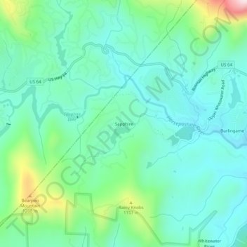
Naam: Topografische kaart Sapphire, hoogte, reliëf.
Gemiddelde hoogte: 997 m
Minimale hoogte: 883 m
Maximale hoogte: 1.371 m
Doe een donatie
Rust jezelf uit voor je volgende avontuur:
Als Amazon-partner verdient deze site een commissie op in aanmerking komende aankopen, zonder extra kosten voor jou.
Andere topografische kaarten
Klik op een kaart om zijn topografie, zijn hoogte en zijn reliëf te bekijken.
Doe een donatie
Rust jezelf uit voor je volgende avontuur:
Als Amazon-partner verdient deze site een commissie op in aanmerking komende aankopen, zonder extra kosten voor jou.
Dupont State Recreational Forest
United States > North Carolina > Transylvania County
Gemiddelde hoogte: 826 m
Pisgah National Forest
United States > North Carolina > Transylvania County
The Pisgah National Forest covers 512,758 acres (801 sq mi; 2,075 km2) of mountainous terrain in the southern Appalachian Mountains, including parts of the Blue Ridge Mountains and Great Balsam Mountains. Elevations reach over 6,000 feet (1,800 m) and include some of the highest mountains in the eastern United…
Gemiddelde hoogte: 752 m
Doe een donatie
Rust jezelf uit voor je volgende avontuur:
Als Amazon-partner verdient deze site een commissie op in aanmerking komende aankopen, zonder extra kosten voor jou.
Dupont State Recreational Forest
United States > North Carolina > Transylvania County
Gemiddelde hoogte: 840 m
Gorges State Park
United States > North Carolina > Transylvania County
Following the flood, local citizens eventually sold large land tracts in the Gorges to Singer Sewing Machine Company, which logged most of the land. Then, in the 1940s and 1950s, Singer sold the land to Duke Energy Corporation. The corporation purchased the land for its steep topography and high rainfall,…
Gemiddelde hoogte: 682 m