
Topografische kaart Montespluga
Interactieve kaart
Klik op de kaart om de hoogte weer te geven.
Over deze kaart
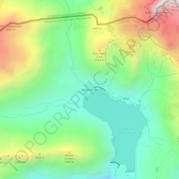
Naam: Topografische kaart Montespluga, hoogte, reliëf.
Gemiddelde hoogte: 2.194 m
Minimale hoogte: 1.748 m
Maximale hoogte: 2.997 m
Montespluga is an Alpine village near the head of the Valle Spluga in the Italian region of Lombardy. It is a frazione of the comune of Madesimo, located at 1,908 m of altitude on the road to Chiavenna.