
Topografische kaart Aluva
Interactieve kaart
Klik op de kaart om de hoogte weer te geven.
Over deze kaart
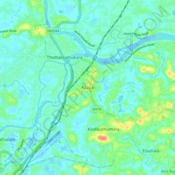
Naam: Topografische kaart Aluva, hoogte, reliëf.
Locatie: Aluva, Ernakulam District, Kerala, 683101, India (10.06041 76.31699 10.14041 76.39699)
Gemiddelde hoogte: 11 m
Minimale hoogte: -2 m
Maximale hoogte: 52 m
Aluva Railway Station is a major stop for trains that passes north to south of Kerala. It is the third busiest station in Kochi city, after Ernakulam Junction railway station and Ernakulam Town railway station. The station is important for southern railway because of the number of passengers itself. The commuters and travellers from Idukki district have to use either this station or the Tripunithura railway station for all their train journeys as there is no possible railway in the Idukki topography. There are no trains starting or ending at this station, but there are a lot of trains which stop for considerable duration here.
Andere topografische kaarten
Klik op een kaart om zijn topografie, zijn hoogte en zijn reliëf te bekijken.
Uravu Kulam
India > Kerala > Aluva > Vengoor
Uravu Kulam, Laksham veedu Colony marottichodu, Vengoor, Aluva, Ernakulam District, Kerala, India
Gemiddelde hoogte: 15 m
Parunth Ranchi Thuruth
India > Kerala > Aluva > Aluva
Parunth Ranchi Thuruth, Aluva, Ernakulam district, Kerala, India
Gemiddelde hoogte: 9 m
Malayattoor
Malayattoor, Aluva, Ernakulam District, Kerala, 683587, India
Gemiddelde hoogte: 19 m