
Topografische kaart Wilsonville
Interactieve kaart
Klik op de kaart om de hoogte weer te geven.
Over deze kaart
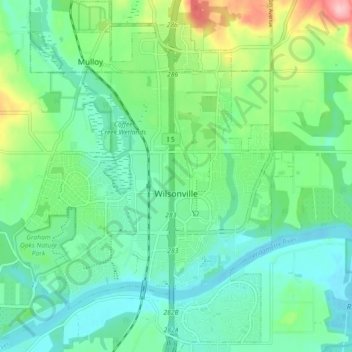
Naam: Topografische kaart Wilsonville, hoogte, reliëf.
Gemiddelde hoogte: 60 m
Minimale hoogte: 18 m
Maximale hoogte: 181 m
Wilsonville is located on the southern edge of the Portland metropolitan area sitting at an elevation of 154 feet (47 m) above sea level. Primarily in the southwestern part of Clackamas County, the northern section is in Washington County. It is located on the north side of the Willamette River around where Alphonse Boone established the Boones Ferry. Neighboring cities are Tualatin on the north, Sherwood to the northwest, and Canby and Aurora to the southeast. Newberg in Yamhill County is approximately 14 miles west along Wilsonville Road. The Willamette separates the majority of the city from Charbonneau, a planned community and neighborhood within the city limits, on the south.
Andere topografische kaarten
Klik op een kaart om zijn topografie, zijn hoogte en zijn reliëf te bekijken.
Colton
United States > Oregon > Clackamas County
Colton, Clackamas County, Oregon, 97017, United States
Gemiddelde hoogte: 228 m
Logan
United States > Oregon > Clackamas County
Logan, Clackamas County, Oregon, United States
Gemiddelde hoogte: 131 m
Fernwood
United States > Oregon > Clackamas County
Fernwood, Clackamas County, Oregon, United States
Gemiddelde hoogte: 317 m
Estacada
United States > Oregon > Clackamas County
Estacada, Clackamas County, Oregon, 97023, United States
Gemiddelde hoogte: 176 m
Sandy
United States > Oregon > Clackamas County
Sandy, Clackamas County, Oregon, 97055, United States
Gemiddelde hoogte: 247 m
Gladstone
United States > Oregon > Clackamas County
Gladstone, Clackamas County, Oregon, 97027, United States
Gemiddelde hoogte: 41 m
Mulino
United States > Oregon > Clackamas County
Mulino, Clackamas County, Oregon, 97042, United States
Gemiddelde hoogte: 100 m
Welches
United States > Oregon > Clackamas County
Welches, Clackamas County, Oregon, 97067, United States
Gemiddelde hoogte: 526 m
Eagle Creek
United States > Oregon > Clackamas County
Eagle Creek, Clackamas County, Oregon, 97022, United States
Gemiddelde hoogte: 120 m
Canby
United States > Oregon > Clackamas County
Canby, Clackamas County, Oregon, 97013, United States
Gemiddelde hoogte: 40 m
Government Camp
United States > Oregon > Clackamas County
Government Camp, Clackamas County, Oregon, 97028, United States
Gemiddelde hoogte: 1.238 m
Lake Oswego
United States > Oregon > Clackamas County
Lake Oswego, Clackamas County, Oregon, United States
Gemiddelde hoogte: 87 m
Oregon City
United States > Oregon > Clackamas County
Oregon City, Clackamas County, Oregon, 97045, United States
Gemiddelde hoogte: 99 m
Rock
United States > Oregon > Clackamas County
Rock, Clackamas County, Oregon, 97032, United States
Gemiddelde hoogte: 45 m
Damascus
United States > Oregon > Clackamas County
Damascus, Clackamas County, Oregon, 97089, United States
Gemiddelde hoogte: 149 m
Happy Valley
United States > Oregon > Clackamas County
Happy Valley, Clackamas County, Oregon, 97086, United States
Gemiddelde hoogte: 138 m
West Linn
United States > Oregon > Clackamas County
West Linn, Clackamas County, Oregon, 97068, United States
Gemiddelde hoogte: 74 m
Sandy Glacier
United States > Oregon > Clackamas County
Sandy Glacier, Clackamas County, Oregon, United States
Gemiddelde hoogte: 2.365 m