
Doe een donatie
Rust jezelf uit voor je volgende avontuur:
Als Amazon-partner verdient deze site een commissie op in aanmerking komende aankopen, zonder extra kosten voor jou.
Topografische kaart Bumbungan River
Klik op de kaart om de hoogte weer te geven.
Doe een donatie
Rust jezelf uit voor je volgende avontuur:
Als Amazon-partner verdient deze site een commissie op in aanmerking komende aankopen, zonder extra kosten voor jou.
Bumbungan River
The waterfalls for which the Bumbungan river is famous is the Magdapio Falls, a section of the river in the town of Cavinti where the river drops about 300 feet (91 m). Because the original boat ride to reach the falls starts in Pagsanjan, it became known as the Pagsanjan Falls. This round trip boat ride consists of a 5.1-kilometre (3.2 mi) trip to the falls in a Filipino banca (dugout canoe with newer ones made with fiberglass), guided by a set of boatmen positioned at each end of the boat, as visitors are taken upriver passing through the narrow Pagsanjan Gorge, which gradually increase in elevation to over hundreds of feet high. The gorge is lined with trees, ferns, overhanging vines, rocks and boulders where varieties of fauna like birds, dragonflies, lizards and monkeys can be observed. The return trip, called Shooting the rapids, is a faster downriver ride as the skilled boatmen maneuvers the banca, avoiding rocks, as it glides through the rapids.
Doe een donatie
Rust jezelf uit voor je volgende avontuur:
Als Amazon-partner verdient deze site een commissie op in aanmerking komende aankopen, zonder extra kosten voor jou.
Over deze kaart
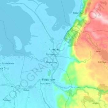
Naam: Topografische kaart Bumbungan River, hoogte, reliëf.
Gemiddelde hoogte: 85 m
Minimale hoogte: -3 m
Maximale hoogte: 410 m
Doe een donatie
Rust jezelf uit voor je volgende avontuur:
Als Amazon-partner verdient deze site een commissie op in aanmerking komende aankopen, zonder extra kosten voor jou.