
Topografische kaart Wayne County
Interactieve kaart
Klik op de kaart om de hoogte weer te geven.
Over deze kaart
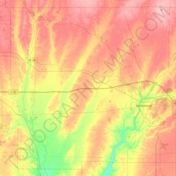
Naam: Topografische kaart Wayne County, hoogte, reliëf.
Locatie: Wayne County, Indiana, United States (39.71477 -85.22151 40.00626 -84.81071)
Gemiddelde hoogte: 322 m
Minimale hoogte: 240 m
Maximale hoogte: 385 m
According to the 2010 census, the county has a total area of 404.34 square miles (1,047.2 km2), of which 401.74 square miles (1,040.5 km2) (or 99.36%) is land and 2.60 square miles (6.7 km2) (or 0.64%) is water. Wayne County includes Indiana's highest natural elevation, Hoosier Hill, at 1,257 feet (383 m).
Andere topografische kaarten
Klik op een kaart om zijn topografie, zijn hoogte en zijn reliëf te bekijken.
Richmond
United States > Indiana > Wayne County
Richmond, Wayne County, Indiana, 47374, United States
Gemiddelde hoogte: 314 m