
Topografische kaart Kalispell
Interactieve kaart
Klik op de kaart om de hoogte weer te geven.
Over deze kaart
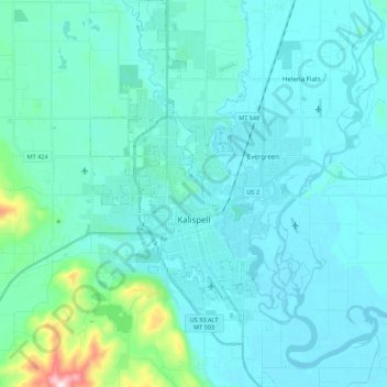
Naam: Topografische kaart Kalispell, hoogte, reliëf.
Locatie: Kalispell, Flathead County, Montana, United States (48.13902 -114.37390 48.28449 -114.26881)
Gemiddelde hoogte: 934 m
Minimale hoogte: 879 m
Maximale hoogte: 1.394 m
Kalispell is located at 48°11′52″N 114°18′58″W / 48.19778°N 114.31611°W / 48.19778; -114.31611 (48.197801, −114.316068), at an elevation of 2,956 feet (901 m).
Andere topografische kaarten
Klik op een kaart om zijn topografie, zijn hoogte en zijn reliëf te bekijken.
Lakeside
United States > Montana > Flathead County
Lakeside, Flathead County, Montana, 59922, United States
Gemiddelde hoogte: 1.034 m
Bowman Lake
United States > Montana > Flathead County
Bowman Lake, Flathead County, Montana, United States
Gemiddelde hoogte: 1.639 m
Martin City
United States > Montana > Flathead County > Martin City
Martin City, Flathead County, Montana, 59926, United States
Gemiddelde hoogte: 989 m
Columbia Falls
United States > Montana > Flathead County
Columbia Falls, Flathead County, Montana, 59912, United States
Gemiddelde hoogte: 934 m
Mount Liebig
United States > Montana > Flathead County
Mount Liebig, Flathead County, Montana, United States
Gemiddelde hoogte: 1.968 m
Whitefish
United States > Montana > Flathead County
Whitefish, Flathead County, Montana, United States
Gemiddelde hoogte: 1.073 m
La Salle
United States > Montana > Flathead County > La Salle
La Salle, Flathead County, Montana, United States
Gemiddelde hoogte: 906 m
Kalispell
United States > Montana > Flathead County > Kalispell
Kalispell, Flathead County, Montana, 59901-4451, United States
Gemiddelde hoogte: 1.055 m
Agassiz Glacier
United States > Montana > Flathead County
Agassiz Glacier, Flathead County, Montana, United States
Gemiddelde hoogte: 2.376 m
Vulture Glacier
United States > Montana > Flathead County
Vulture Glacier, Flathead County, Montana, United States
Gemiddelde hoogte: 2.381 m