
Topografische kaart Garden City
Interactieve kaart
Klik op de kaart om de hoogte weer te geven.
Garden City
Garden City is at 37°58′31″N 100°51′51″W / 37.97528°N 100.86417°W / 37.97528; -100.86417 at an elevation of 2,838 feet (865 m). The city lies on the north side of the Arkansas River in the High Plains region of the Great Plains. It is located in southwestern Kansas at the intersection of U.S. Route 50 and U.S. Route 83, Garden City is 192 miles (309 km) west-northwest of Wichita, 204 miles (328 km) north-northeast of Amarillo, and 255 miles (410 km) southeast of Denver. According to the United States Census Bureau, the city has a total area of 8.82 square miles (22.84 km2), all land. It is the most remote city in America with population over 25,000.
Over deze kaart
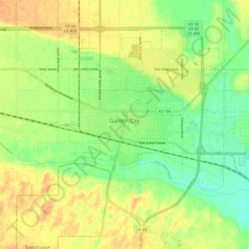
Naam: Topografische kaart Garden City, hoogte, reliëf.
Locatie: Garden City, Finney County, Kansas, 67846, United States (37.93694 -100.90168 38.00357 -100.79251)
Gemiddelde hoogte: 870 m
Minimale hoogte: 852 m
Maximale hoogte: 886 m
Andere topografische kaarten
Klik op een kaart om zijn topografie, zijn hoogte en zijn reliëf te bekijken.
Garden City
United States > Kansas > Finney County > Garden City > Garden City
Gemiddelde hoogte: 882 m