
Topografische kaart Sierra de Guadarrama
Interactieve kaart
Klik op de kaart om de hoogte weer te geven.
Over deze kaart
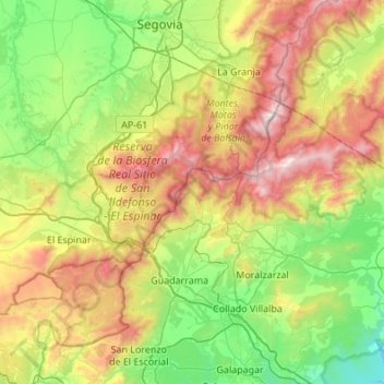
Naam: Topografische kaart Sierra de Guadarrama, hoogte, reliëf.
Gemiddelde hoogte: 1.241 m
Minimale hoogte: 640 m
Maximale hoogte: 2.421 m
The range runs southwest–northeast, extending from the province of Ávila in the southwest, through the Community of Madrid, to the province of Segovia in the northeast. The range measures approximately 80 kilometres (50 mi) in length. Its highest peak is Peñalara, 2,428 metres (7,966 ft) in elevation.