
Topografische kaart Hudson
Interactieve kaart
Klik op de kaart om de hoogte weer te geven.
Over deze kaart
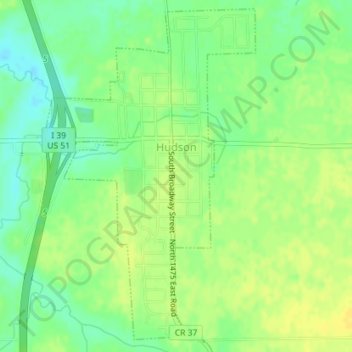
Naam: Topografische kaart Hudson, hoogte, reliëf.
Locatie: Hudson, McLean County, Illinois, United States (40.59082 -89.00085 40.61647 -88.97929)
Gemiddelde hoogte: 234 m
Minimale hoogte: 222 m
Maximale hoogte: 243 m
Andere topografische kaarten
Klik op een kaart om zijn topografie, zijn hoogte en zijn reliëf te bekijken.
Towanda
United States > Illinois > McLean County
Towanda, McLean County, Illinois, 61776, United States
Gemiddelde hoogte: 239 m
Bloomington
United States > Illinois > McLean County
Bloomington, McLean County, Illinois, United States
Gemiddelde hoogte: 246 m
Clarksville
United States > Illinois > McLean County
Clarksville, McLean County, Illinois, United States
Gemiddelde hoogte: 224 m
Bellflower
United States > Illinois > McLean County
Bellflower, McLean County, Illinois, 61724, United States
Gemiddelde hoogte: 235 m
Heyworth
United States > Illinois > McLean County > Heyworth
Heyworth, McLean County, Illinois, United States
Gemiddelde hoogte: 227 m
Normal
United States > Illinois > McLean County
Normal, McLean County, Illinois, United States
Gemiddelde hoogte: 249 m