
Topografische kaart Hacksneck
Interactieve kaart
Klik op de kaart om de hoogte weer te geven.
Over deze kaart
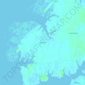
Naam: Topografische kaart Hacksneck, hoogte, reliëf.
Locatie: Hacksneck, Accomack County, Virginia, 23358, United States (37.62319 -75.89049 37.66319 -75.85049)
Gemiddelde hoogte: 1 m
Minimale hoogte: -2 m
Maximale hoogte: 11 m
Andere topografische kaarten
Klik op een kaart om zijn topografie, zijn hoogte en zijn reliëf te bekijken.
Cheeseman Island
United States > Virginia > Accomack County
Cheeseman Island, Accomack County, Virginia, 21866, United States
Gemiddelde hoogte: 2 m
Painter
United States > Virginia > Accomack County
Painter, Accomack County, Virginia, United States
Gemiddelde hoogte: 10 m
Tangier Island
United States > Virginia > Accomack County > Tangier
Tangier Island, Tangier, Accomack County, Virginia, 23440, United States
Gemiddelde hoogte: 2 m
Deep Creek
United States > Virginia > Accomack County
Deep Creek, Accomack County, Virginia, United States
Gemiddelde hoogte: 1 m
Wishart
United States > Virginia > Accomack County > Wishart
Wishart, Accomack County, Virginia, 23303, United States
Gemiddelde hoogte: 5 m
Herring Island
United States > Virginia > Accomack County
Herring Island, Accomack County, Virginia, United States
Gemiddelde hoogte: 2 m
Old Beach
United States > Virginia > Accomack County
Old Beach, Accomack County, Virginia, United States
Gemiddelde hoogte: 2 m