
Topografische kaart Hillsdale
Interactieve kaart
Klik op de kaart om de hoogte weer te geven.
Over deze kaart
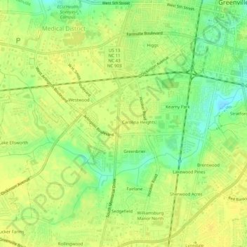
Naam: Topografische kaart Hillsdale, hoogte, reliëf.
Gemiddelde hoogte: 20 m
Minimale hoogte: 6 m
Maximale hoogte: 27 m
Andere topografische kaarten
Klik op een kaart om zijn topografie, zijn hoogte en zijn reliëf te bekijken.
Sedgefield
United States > North Carolina > Pitt County > Greenville
Sedgefield, Greenville, Pitt County, North Carolina, 28950, United States
Gemiddelde hoogte: 22 m
Pinewood Forest
United States > North Carolina > Pitt County > Greenville
Pinewood Forest, Greenville, Pitt County, North Carolina, 28590, United States
Gemiddelde hoogte: 23 m
Westhaven
United States > North Carolina > Pitt County > Greenville
Westhaven, Greenville, Pitt County, North Carolina, 28590, United States
Gemiddelde hoogte: 23 m
Hartington and Williams
United States > North Carolina > Pitt County > Greenville
Hartington and Williams, Greenville, Pitt County, North Carolina, 27858, United States
Gemiddelde hoogte: 13 m
Biltmore
United States > North Carolina > Pitt County > Greenville > Biltmore
Biltmore, Greenville, Pitt County, North Carolina, 27834, United States
Gemiddelde hoogte: 13 m