
Doe een donatie
Rust jezelf uit voor je volgende avontuur:
Als Amazon-partner verdient deze site een commissie op in aanmerking komende aankopen, zonder extra kosten voor jou.
Topografische kaart Melfi
Klik op de kaart om de hoogte weer te geven.
Doe een donatie
Rust jezelf uit voor je volgende avontuur:
Als Amazon-partner verdient deze site een commissie op in aanmerking komende aankopen, zonder extra kosten voor jou.
Melfi
The Castle, dominates the whole town. It was probably constructed ex novo by the Normans (11th century), as no trace of pre-existing Byzantine or Lombard edifices has been found. Originally, it was probably a simple rectangle with square towers, with further towers defending the main gate. One of the main internal buildings was later (16th-18th centuries) turned into a baronial palace by enclosing the walls between the towers within new walls. Under the Angevine rule a new section was added on the slope descending to the Melfia stream, with several constructions rising at different altitudes. The Castle was chosen by King Charles II's wife, Mary of Hungary, as her residence. The Aragon kings gave it to the Caracciolo family, who rebuilt the side facing the city and dug a moat. Later it was a possession of the powerful House of Doria.
Doe een donatie
Rust jezelf uit voor je volgende avontuur:
Als Amazon-partner verdient deze site een commissie op in aanmerking komende aankopen, zonder extra kosten voor jou.
Over deze kaart
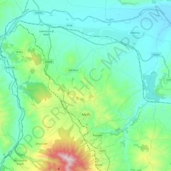
Naam: Topografische kaart Melfi, hoogte, reliëf.
Locatie: Melfi, Potenza, Basilicata, 85025, Italy (40.94867 15.54287 41.10055 15.76704)
Gemiddelde hoogte: 377 m
Minimale hoogte: 138 m
Maximale hoogte: 1.299 m
Doe een donatie
Rust jezelf uit voor je volgende avontuur:
Als Amazon-partner verdient deze site een commissie op in aanmerking komende aankopen, zonder extra kosten voor jou.
Andere topografische kaarten
Klik op een kaart om zijn topografie, zijn hoogte en zijn reliëf te bekijken.