
Topografische kaart Ghumarwin
Interactieve kaart
Klik op de kaart om de hoogte weer te geven.
Over deze kaart
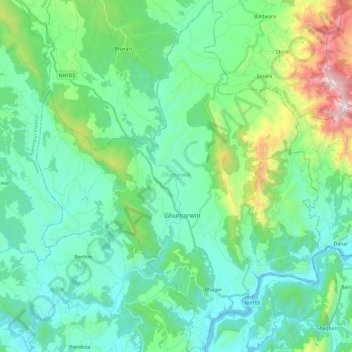
Naam: Topografische kaart Ghumarwin, hoogte, reliëf.
Locatie: Ghumarwin, Bilaspur, Himachal Pradesh, India (31.36262 76.60792 31.56707 76.80162)
Gemiddelde hoogte: 774 m
Minimale hoogte: 486 m
Maximale hoogte: 1.857 m
Andere topografische kaarten
Klik op een kaart om zijn topografie, zijn hoogte en zijn reliëf te bekijken.
Bilaspur
India > Himachal Pradesh > Bilaspur
Bilaspur, Himachal Pradesh, 174001, India
Gemiddelde hoogte: 738 m
Swarghat
India > Himachal Pradesh > Bilaspur > Swarghat
Swarghat, Bilaspur, Himachal Pradesh, 174011, India
Gemiddelde hoogte: 983 m
Bharari
India > Himachal Pradesh > Bilaspur
Bharari, Bilaspur, Himachal Pradesh, India
Gemiddelde hoogte: 791 m