
Topografische kaart Colonia Cuauhtémoc
Interactieve kaart
Klik op de kaart om de hoogte weer te geven.
Over deze kaart
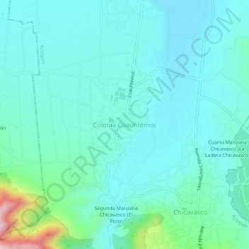
Naam: Topografische kaart Colonia Cuauhtémoc, hoogte, reliëf.
Locatie: Colonia Cuauhtémoc, Actopan, Hidalgo, 42601, México (20.18939 -98.98536 20.22939 -98.94536)
Gemiddelde hoogte: 2.052 m
Minimale hoogte: 1.987 m
Maximale hoogte: 2.381 m
Andere topografische kaarten
Klik op een kaart om zijn topografie, zijn hoogte en zijn reliëf te bekijken.
El Huaxtho
El Huaxtho, Actopan, Hidalgo, 42601, México
Gemiddelde hoogte: 2.005 m