
Topografische kaart Bridgewater
Interactieve kaart
Klik op de kaart om de hoogte weer te geven.
Over deze kaart
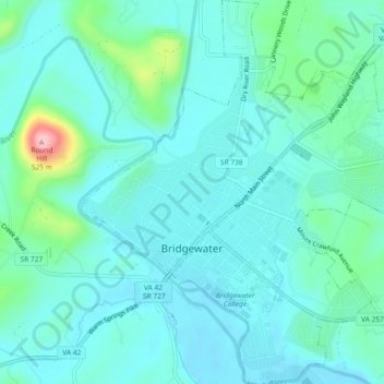
Naam: Topografische kaart Bridgewater, hoogte, reliëf.
Locatie: Bridgewater, Rockingham County, Virginia, United States (38.36928 -78.98997 38.40543 -78.94621)
Gemiddelde hoogte: 380 m
Minimale hoogte: 351 m
Maximale hoogte: 515 m
According to the United States Census Bureau, the town has a total area of 2.52 sq mi (6.5 km2), nearly all of it being land. Most of the town is located within a bend of the North River. Floods have wrecked the town occasionally. The northern areas are partly shielded from flooding with an Army Corps of Engineers dam. The wooded monadnock called Round Hill (elevation approx. 1750 feet) dominates the town's western skyline.
Andere topografische kaarten
Klik op een kaart om zijn topografie, zijn hoogte en zijn reliëf te bekijken.
Dale Enterprise
United States > Virginia > Rockingham County
Dale Enterprise, Rockingham County, Virginia, United States
Gemiddelde hoogte: 427 m