
Topografische kaart Marble Rock
Interactieve kaart
Klik op de kaart om de hoogte weer te geven.
Over deze kaart
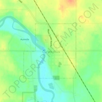
Naam: Topografische kaart Marble Rock, hoogte, reliëf.
Locatie: Marble Rock, Floyd County, Iowa, 50653, United States (42.95797 -92.87835 42.97248 -92.85941)
Gemiddelde hoogte: 308 m
Minimale hoogte: 290 m
Maximale hoogte: 327 m
Andere topografische kaarten
Klik op een kaart om zijn topografie, zijn hoogte en zijn reliëf te bekijken.
Charles City
United States > Iowa > Floyd County
Charles City, Floyd County, Iowa, 50616, United States
Gemiddelde hoogte: 315 m
Rockford
United States > Iowa > Floyd County
Rockford, Floyd County, Iowa, United States
Gemiddelde hoogte: 311 m
Floyd
United States > Iowa > Floyd County
Floyd, Floyd County, Iowa, United States
Gemiddelde hoogte: 323 m
Colwell
United States > Iowa > Floyd County
Colwell, Floyd County, Iowa, United States
Gemiddelde hoogte: 343 m
Nora Springs
United States > Iowa > Floyd County
Nora Springs, Floyd County, Iowa, 50458, United States
Gemiddelde hoogte: 333 m
Rudd
United States > Iowa > Floyd County
Rudd, Floyd County, Iowa, United States
Gemiddelde hoogte: 339 m