
Topografische kaart Koshi River
Interactieve kaart
Klik op de kaart om de hoogte weer te geven.
Over deze kaart
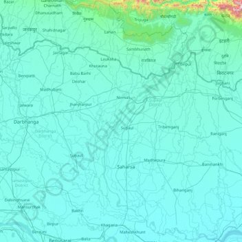
Naam: Topografische kaart Koshi River, hoogte, reliëf.
Locatie: Koshi River, Bihar, India (25.40379 86.43871 26.91017 87.26669)
Gemiddelde hoogte: 82 m
Minimale hoogte: 24 m
Maximale hoogte: 1.960 m
The Kosi River catchment covers six geological and climatic belts varying in altitude from above 8,000 m (26,000 ft) to 95 m (312 ft) comprising the Tibetan plateau, the Himalayas, the Himalayan mid-hill belt, the Mahabharat Range, the Siwalik Hills and the Terai. The Dudh-Koshi sub-basin alone consists of 36 glaciers and 296 glacier lakes. The Kosi River basin borders the Tsangpo River basin in the north, the Mahananda River basin in the east, the Ganges Basin in the south and the Gandaki River basin in the west. The eight tributaries of the basin upstream the Chatra Gorge include from east to west:
Andere topografische kaarten
Klik op een kaart om zijn topografie, zijn hoogte en zijn reliëf te bekijken.
Patna
India > Bihar > Patna Rural
Patna, Patna Rural, Patna District, Bihar, 800001, India
Gemiddelde hoogte: 51 m
Sultanganj
India > Bihar > Sultanganj
Sultanganj, Bhagalpur District, Bihar, 812006, India
Gemiddelde hoogte: 35 m
Parmanandpur
Parmanandpur, Basantpur, Supaul, Bihar, India
Gemiddelde hoogte: 76 m
Gaya
India > Bihar > Gaya Town C.D.Block
Gaya, Gaya Town C.D.Block, Gaya District, Bihar, 823001, India
Gemiddelde hoogte: 111 m
Baruraj (Motipur)
India > Bihar > Baruraj (Motipur)
Baruraj (Motipur), Muzaffarpur, Bihar, 843132, India
Gemiddelde hoogte: 58 m
Manikpur
India > Bihar > Narpatganj
Manikpur, Narpatganj, Araria, Bihar, 854336, India
Gemiddelde hoogte: 70 m
Sonbhadra Banshi Suryapur
Sonbhadra Banshi Suryapur, Arwal, Bihar, India
Gemiddelde hoogte: 76 m