
Topografische kaart Magnolia
Interactieve kaart
Klik op de kaart om de hoogte weer te geven.
Magnolia
Magnolia is located in southwest Arkansas, north of the center of Columbia County. The average altitude is 336 ft (102 m) above sea level according to NOAA. The surrounding region is a mix of dense forest, farm prairies, and low rolling hills.
Over deze kaart
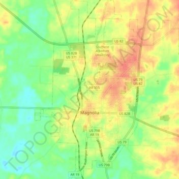
Naam: Topografische kaart Magnolia, hoogte, reliëf.
Locatie: Magnolia, Columbia County, Arkansas, United States (33.23838 -93.26766 33.31554 -93.18919)
Gemiddelde hoogte: 91 m
Minimale hoogte: 66 m
Maximale hoogte: 117 m
Andere topografische kaarten
Klik op een kaart om zijn topografie, zijn hoogte en zijn reliëf te bekijken.