
Topografische kaart Riverside
Interactieve kaart
Klik op de kaart om de hoogte weer te geven.
Riverside
Riverside is the 59th largest city in the United States, the 12th largest city in California, and the largest city in California's Inland Empire metro area. According to the United States Census Bureau, the city has a total area of 81.4 square miles (210.8 km2), of which 81.1 square miles (210 km2) is land and 0.3 square miles (0.78 km2) (0.37%) is water. The elevation of downtown Riverside is 860 feet (260 m). Hills within the city limits include Mount Rubidoux, a city landmark and tourist attraction. Riverside is surrounded by small and large mountains, some of which get a dusting of winter snow. Many residents also enjoy the many beaches of Southern California. Riverside is about a 47-mile drive to the Pacific Ocean and is close to Orange County and Los Angeles County.
Over deze kaart
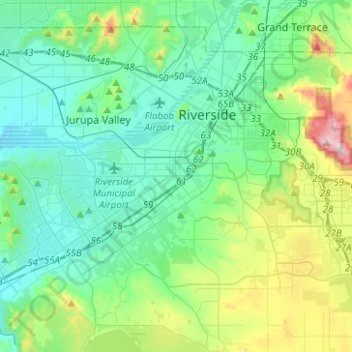
Naam: Topografische kaart Riverside, hoogte, reliëf.
Gemiddelde hoogte: 351 m
Minimale hoogte: 191 m
Maximale hoogte: 932 m
Andere topografische kaarten
Klik op een kaart om zijn topografie, zijn hoogte en zijn reliëf te bekijken.
Canyon Crest
United States of America > California > Riverside > Canyon Crest
Gemiddelde hoogte: 372 m
Riverside Junction
United States of America > California > Riverside > Riverside Junction
Gemiddelde hoogte: 273 m