
Topografische kaart McLouth
Interactieve kaart
Klik op de kaart om de hoogte weer te geven.
Over deze kaart
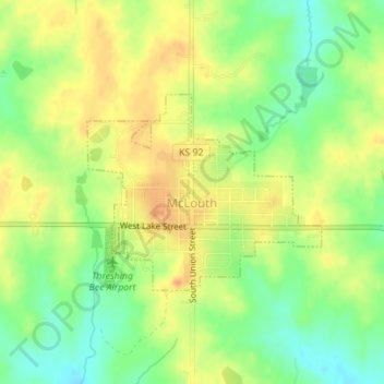
Naam: Topografische kaart McLouth, hoogte, reliëf.
Locatie: McLouth, Jefferson County, Kansas, United States (39.18969 -95.21782 39.20347 -95.19653)
Gemiddelde hoogte: 350 m
Minimale hoogte: 327 m
Maximale hoogte: 369 m
Andere topografische kaarten
Klik op een kaart om zijn topografie, zijn hoogte en zijn reliëf te bekijken.
Oskaloosa
United States > Kansas > Jefferson County
Oskaloosa, Jefferson County, Kansas, United States
Gemiddelde hoogte: 329 m
Winchester
United States > Kansas > Jefferson County
Winchester, Jefferson County, Kansas, United States
Gemiddelde hoogte: 352 m
Nortonville
United States > Kansas > Jefferson County
Nortonville, Jefferson County, Kansas, 66060, United States
Gemiddelde hoogte: 348 m
Valley Falls
United States > Kansas > Jefferson County
Valley Falls, Jefferson County, Kansas, United States
Gemiddelde hoogte: 288 m
Perry
United States > Kansas > Jefferson County
Perry, Jefferson County, Kansas, United States
Gemiddelde hoogte: 261 m
Valley Falls
United States > Kansas > Jefferson County > Valley Falls > Valley Falls
Valley Falls, Jefferson County, Kansas, 66088, United States
Gemiddelde hoogte: 296 m