
Topografische kaart St. John's in the Vale
Interactieve kaart
Klik op de kaart om de hoogte weer te geven.
Over deze kaart
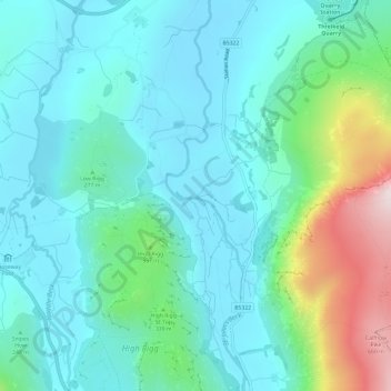
Naam: Topografische kaart St. John's in the Vale, hoogte, reliëf.
Gemiddelde hoogte: 256 m
Minimale hoogte: 134 m
Maximale hoogte: 706 m
Andere topografische kaarten
Klik op een kaart om zijn topografie, zijn hoogte en zijn reliëf te bekijken.
St. John's Beck
United Kingdom > England > Cumberland > Legburthwaite
St. John's Beck, Legburthwaite, Cumberland, England, CA12 4TG, United Kingdom
Gemiddelde hoogte: 311 m