
Topografische kaart Stradbally
Interactieve kaart
Klik op de kaart om de hoogte weer te geven.
Over deze kaart
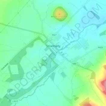
Naam: Topografische kaart Stradbally, hoogte, reliëf.
Gemiddelde hoogte: 92 m
Minimale hoogte: 69 m
Maximale hoogte: 167 m
Andere topografische kaarten
Klik op een kaart om zijn topografie, zijn hoogte en zijn reliëf te bekijken.
Mountmellick
Mountmellick, The Municipal District of Borris-in-Ossory — Mountmellick, County Laois, Leinster, Ireland
Gemiddelde hoogte: 76 m
Burke's Cross
Burke's Cross, Lacka ED, The Municipal District of Borris-in-Ossory — Mountmellick, County Laois, Leinster, Ireland
Gemiddelde hoogte: 195 m
Trumra Rock
Trumra Rock, Trumra ED, The Municipal District of Borris-in-Ossory — Mountmellick, County Laois, Leinster, Ireland
Gemiddelde hoogte: 105 m
Timahoe
Timahoe, The Municipal District of Graiguecullen — Portarlington, County Laois, Leinster, R32 Y09T, Ireland
Gemiddelde hoogte: 146 m
The Municipal District of Portlaoise
The Municipal District of Portlaoise, County Laois, Leinster, Ireland
Gemiddelde hoogte: 138 m
The Municipal District of Graiguecullen — Portarlington
The Municipal District of Graiguecullen — Portarlington, County Laois, Leinster, Ireland
Gemiddelde hoogte: 113 m
Killadooley
Killadooley, Ballybrophy ED, The Municipal District of Borris-in-Ossory — Mountmellick, County Laois, Leinster, Ireland
Gemiddelde hoogte: 122 m