
Topografische kaart Dulce
Interactieve kaart
Klik op de kaart om de hoogte weer te geven.
Over deze kaart
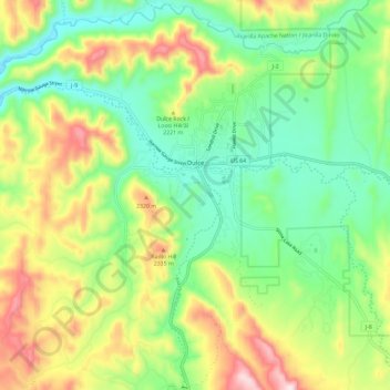
Naam: Topografische kaart Dulce, hoogte, reliëf.
Locatie: Dulce, Rio Arriba County, New Mexico, 87528, United States (36.87926 -107.05997 36.97227 -106.95423)
Gemiddelde hoogte: 2.179 m
Minimale hoogte: 2.017 m
Maximale hoogte: 2.454 m
Dulce is the southernmost urban area with a subarctic humid continental climate in North America (Köppen: Dfc) where summer is mild and short due to high altitude and rigorous winter. Going further south than the Dfb in low altitude and in latitude similar to the southern limit of the Dfa in the center of the country.
Andere topografische kaarten
Klik op een kaart om zijn topografie, zijn hoogte en zijn reliëf te bekijken.
Fairview
United States > New Mexico > Rio Arriba County > Espanola
Fairview, Espanola, Rio Arriba County, New Mexico, 87532, United States
Gemiddelde hoogte: 1.720 m
Coyote
United States > New Mexico > Rio Arriba County
Coyote, Rio Arriba County, New Mexico, 87012, United States
Gemiddelde hoogte: 2.115 m
Cerro Pedernal
United States > New Mexico > Rio Arriba County
Cerro Pedernal, Rio Arriba County, New Mexico, United States
Gemiddelde hoogte: 2.631 m
Toltec
United States > New Mexico > Rio Arriba County > Toltec
Toltec, Rio Arriba County, New Mexico, United States
Gemiddelde hoogte: 2.876 m
Lindrith
United States > New Mexico > Rio Arriba County > Lindrith
Lindrith, Rio Arriba County, New Mexico, United States
Gemiddelde hoogte: 2.211 m
Chama
United States > New Mexico > Rio Arriba County
Chama, Rio Arriba County, New Mexico, 87520, United States
Gemiddelde hoogte: 2.435 m